|
||||||||||||
| NR Department | About NRL | Geo-information | ||||||||||
| FAO home |
|
|||||||||||
 |
|
|||||||
|
||||||||
| last update: March 7, 2014 2:51 PM | ||||||||
|
||||||||||||||||||||||||||||||||||||||||||||||||
 |
|
 |
||||||
 |
||||||||
 | ||||||||||||||||||||||||||||
|
|
|||||||||||||||||||||||||||
|
For questions or comments, contact us -
last update:
March 7, 2014 2:51 PM
|


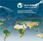 GLC-SHARE database of year 2014, beta-release 1.0, is a global land cover data under one roof
representing the most-reliable global view of planetary land cover assembled to-date. Click here for more
GLC-SHARE database of year 2014, beta-release 1.0, is a global land cover data under one roof
representing the most-reliable global view of planetary land cover assembled to-date. Click here for more
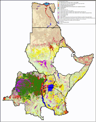 FAO just made
publicly available the full resolution land cover datasetd of the
AFRICOVER project: Burundi, DRC, Egypt, Eritrea, Kenya, Rwanda,
Somalia, Sudan, Tanzania and Uganda.
[
FAO just made
publicly available the full resolution land cover datasetd of the
AFRICOVER project: Burundi, DRC, Egypt, Eritrea, Kenya, Rwanda,
Somalia, Sudan, Tanzania and Uganda.
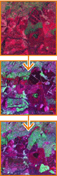
[ MAD-CAT
is a stand alone application that integrates land cover mapping,
change detection and validation functions. It allows delineations from
satellite imagery using object-based classification techniques.
[
MAD-CAT
is a stand alone application that integrates land cover mapping,
change detection and validation functions. It allows delineations from
satellite imagery using object-based classification techniques.
[